A brainchild of Stanford Conservation and a collaboration between Stanford’s Conservation, Tourism & Business and Ratepayer Associations, this plan’s aim is to improve various areas that are of heritage, environmental and socio-economic significance to the community. It was drawn up in 2014 by members of the community for the community, accepted in principle by the Overstrand Municipality, and included in the municipal IDP process as from 2016. The latter is extremely important as it allows for municipal funds to be allocated to the project, as well as for external funding proposals for the various aspects of the Revitalisation plan.
There are four areas of focus:
- The Queen Victoria Street precinct
- The Village Green precinct;
- The open space / river corridor; and
- The Community Centre precinct.
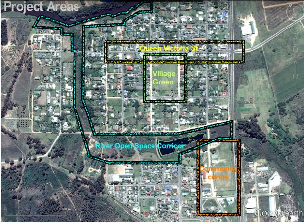
QUEEN VICTORIA STREET PRECINCT
The concept is to create a user-friendly main road that pays tribute to the importance of foot traffic rather than parked cars. By opening up enclosed spaces, literally ‘breaking down fences’ and creating piazzas that could be used after hours and on weekends for social gatherings the intention is create a vibrant tourism environment that will improve business (and therefore socio-economic development) in the village and includes the transformation of the entrance to Stanford (which is at present taking place as part of the R43 upgrade).
Click here for more information on the look and feel of this plan
VILLAGE GREEN PRECINCT
This is one of the few remaining undeveloped ‘market squares’ in South Africa and is therefore of significant heritage grading. In order to make the Queen Victoria Street precinct feasible, additional parking space needs to be created in a manner that will compliment the heritage status of the village, yet provide for developmental needs.
To this end the two existing roads that are part of the village green need to be paved in order to retain the undeveloped character, yet provide for the (dust-free) needs of the residents abutting the village green. Various options have been proposed, which will be taken into consideration by the municipality as funds become available for the upgrading of the village green.
Click here for more information on this plan
THE OPEN SPACE / RIVER CORRIDOR
The Mill Stream (the overflow of water from the natural spring that is Stanford’s main water source and which is supplemented by additional groundwater) is of extreme socio-economic importance. Although a natural phenomenon, it is regarded by a large section of the community as a legacy of the apartheid regime.
The intention is to improve the area by improving the water quality in the stream (and the existing dammed area), by removing all invasive vegetation and by opening up the banks so that they can be used as a recreational area. Click here for a more detailed description.
COMMUNITY CENTRE PRECINCT
The plan is to develop this area into an inter-cultural small business/tourism and sport hub. The road in this precinct is the bloodline between Stanford’s communities and the entire area (road included) needs to be upgraded to provide socio-economic opportunities for the entire community. On the one side of the road are a completely under-utilised Community Hall and a beautiful picnic area that needs to become more community-friendly and linked to the river corridor. On the other side of the road are numerous sport facilities.
The intention is to link the sport fields and the community hall (thus improving the utilisation of both facilities) and to build additional structures that will facilitate sustainable small business development, instil community pride and result in collaboration between Stanford’s diverse communities.